


By the Cuban Institute of Meteorology
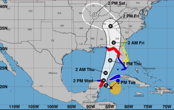
HAVANA TIMES – This afternoon, Helene has moved west-northwest, showing signs of better organization, with an increase in rainfall areas near its center of circulation. Its maximum sustained winds have increased to 85 kilometers per hour (50 mph) with higher gusts, and its minimum pressure has dropped to 995 millibars.
At 6 p.m. (Cuban and ET time), the central region of the tropical storm was estimated at 19.8 degrees north latitude and 84.9 degrees west longitude, positioning it about 235 kilometers (145 mph) south of Cape San Antonio, the westernmost tip of Cuba. It is moving in a west-northwest direction at a speed of 19 kilometers an hour (12 mph).
Over the next 12 to 24 hours, it will continue moving through the far western Caribbean Sea, gradually shifting its path toward the northwest tonight and to the north-northwest by early morning, while slightly reducing its forward speed. Helene will continue to gain organization and intensity, and it may become a hurricane by Wednesday, as it enters the Gulf of Mexico.
With this forecast, the rains that have already been reported this afternoon in the will gradually increase in western and central Cuba, potentially becoming heavy and intense in some areas. The rain will persist throughout tonight and Wednesday, possibly continuing until Thursday.
Starting tonight, tropical storm-force winds may be reported in Isla de la Juventud and Pinar del Río, with speeds between 55 and 70 kilometers per hour, possibly extending by early Wednesday morning to the province of Artemisa. In the westernmost part of Cuba, wind strength will increase starting early tomorrow.
There will be sea swells along the southern coast of the provinces from Pinar del Río to Sancti Spiritus, reaching strong surges south of Isla de la Juventud and the Canarreos Archipelago, as well as on both coasts of Pinar del Rio province, with light to moderate coastal flooding in the southwestern coastal areas.
In areas of showers and thunderstorms, there may be an increase in wind strength and wave height, even in zones far from the center of this tropical storm’s circulation.
The next tropical cyclone advisory from this organization will be issued at midnight tomorrow, Wednesday.
Read more from Cuba here on Havana Times.


