

By Circles Robinson
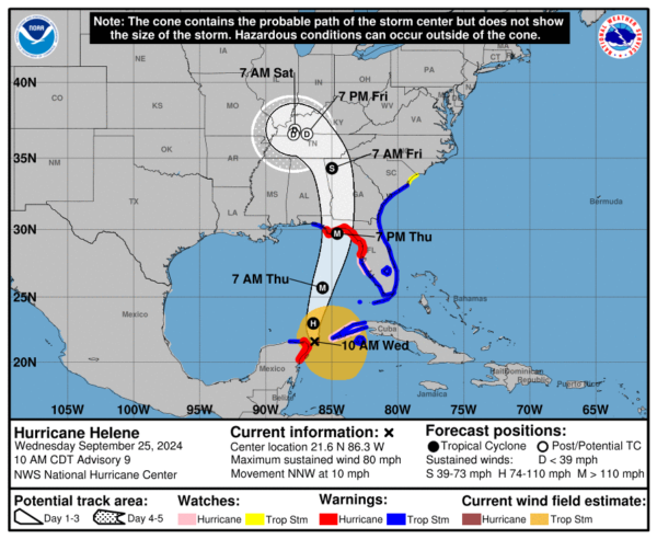
HAVANA TIMES – Helene is now of hurricane strength as it moves into the Yucatan Channel between the tip of far western Cuba and the northeast tip of the Yucatan peninsula. Entering the Gulf of Mexico, Helene is expected to rapidly gain strength and become a major hurricane before it reaches land most likely on the Florida Panhandle on Thursday evening.
At 11:00 AM (ET) the center of the storm was located 85 miles (135 kilometers) North North-East of Cozumel, México and about 500 miles (810 kms) from Tampa, Florida. The hurricane now pacts 80 mph (130 kph) maximum sustained winds and higher gusts. It is presently moving North-North-West at 10 mph (17 kms). The minimum central pressure has dropped to 979 millibars.
Hurricane warnings and are in affect for the entire Florida Panhandle and the west coast of Florida down to Tampa Bay, Tropical Storm warnings are in effect south of Tampa as well as the entire east coast of Florida. The northeast of Mexico’s Yucatan Peninsula is under a hurricane warning while Pinar del Rio, Cuba remains under a Tropical Storm warning.
Wind and rain in western Cuba
The Cuban Weather Service (INSMET) reported this morning that the rains associated with Helene have affected mainly western Cuba and are now extending towards the central region. The highest accumulations since 8 pm yesterday until 5 am today were reported in: Punta del Este, Isla de la Juventud with 101 millimeters, Paso Real de San Diego with 78 millimeters, Pinar del Río with 72 millimeters and Isabel Rubio with 70 millimeters, all in the province of Pinar del Río. (25,.4 millimeters=1 inch of rain)
INSMET said the rains will continue in the western and central regions of Cuba, and will be strong and intense in some localities, and may persist until Thursday.
Winds of 55 to 70 kph (35 to 45 mph) may extend to the province of Artemisa this morning. In the rest of the western provinces, wind speeds will be between 40 and 55 kilometers per hour, (25 to 35 mph) with higher gusts.
Storm surges will occur on the southern coast of the provinces from Pinar del Río to Sancti Spíritus, reaching strongest south of Isla de la Juventud as well as on both coasts of the province of Pinar del Rio, with light to moderate coastal flooding on the southwestern coast, reported INSMET.
Read more news here on Havana Times.

